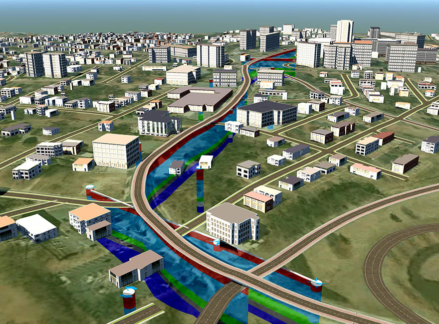
BIM encourages collaboration and the sharing of data between geotechnical contractors and consultants, along with central data management, can deliver big improvements in efficiency and quality.– Gary Morin, Keynetix
Incorporating geotechnical data in BIM can have a positive impact throughout a project’s lifetime, says Gary Morin.
There are a number of benefits to applying BIM principles to geotechnical data management and to including geotechnical data in BIM, not least the potential savings that can be realised if ground-related problems are identified early on in a project.
This can avoid costly design changes that can arise if any issues are uncovered during construction.
Focusing site investigation to deliver value for money
Site investigations are fundamentally about identifying anomalies in the ground that, if left unidentified, can add considerable cost to a project.
The process of geotechnical BIM starts at the desk study stage when compiling and visualising data from a variety of sources (historic boreholes, site investigation reports, geological survey maps and so on), enabling a better understanding of what is going on, even before a spade (or borehole tool) is put in the ground.
Of course, the desk study must be carried out in the context of the project, so incorporating designs and plans (from the overall project BIM, for example) can ensure the site investigation is building on, and enhancing, prior knowledge, rather than starting from scratch: it allows sampling, monitoring and testing to be optimised from the outset, offering better value for money in the long run.
Reacting faster to investigate potential issues
Nothing beats having a geotechnical engineer on site, who is able to respond to what comes out of the ground during the investigation.
However, this is not always the case, but even if it is, BIM can play an important role in the process, as it enables investigation findings to be visualised quickly in the context of the site model (if, for example, an area of weak, waterlogged ground coincides with a heavy load from a proposed structure), often within hours.
This makes it easier to refine investigations as they proceed. An extra borehole can be sunk, more samples can be taken and instrumentation can be installed at relatively low cost. If data is only analysed once fieldwork is over, it can be too late, and too expensive, to investigate further.
Getting the complete picture
Geotechnics is like peering at a painting through pinholes – each one gives only limited detail. It is how these details are pieced together that counts when building a complete picture of the ground.
Geotechnical BIM offers two benefits in this regard. First, the ability to compile large amounts of data from different sources creates a more comprehensive 3D picture of the ground and second, the ease of drawing cross-sections (in seconds, not hours) allows the model to be viewed from a number of different angles.

Seeing the whole picture also allows engineers to identify gaps in the data and knowledge
As a result, geotechnical engineers can gain a better understanding of the ground conditions and are more likely to spot any potential issues.
Seeing the whole picture also allows engineers to identify gaps in the data and knowledge. There are a number of tools available that enable faster gap analysis, identifying when more information is required quickly, opening up the possibility of carrying out further investigation while the teams are still on site.
Collaborating to improve design and construction
BIM encourages collaboration and the sharing of data between geotechnical contractors and consultants, along with central data management, can deliver big improvements in efficiency and quality.
The ability to visualise and share complex geotechnical problems within the design and construction teams can also add value to the geotechnical data. A 3D model can bring the geotechnical report to life, enabling non-geotechnical professionals to relate to, and fully-understand, how problems in the ground could affect the project and start to develop and optimise solutions to deal with them.
However, one of the biggest sticking points for geotechnical BIM has been a reluctance by some practitioners to share interpreted data. While sharing of factual data is common between site investigation companies, laboratories and geotechnical consultants, anecdotal evidence suggests it is rarely shared with the rest of the project team, because geotechnical teams are concerned by the possibility of interpretative data being misused.
Fortunately, as confidence in BIM has grown, and tools such as 3D fence diagram software (allowing rapid viewing of interpreted data) have become available, so have attitudes.
It is accepted by forward-thinking geotechnical professionals that better data sharing leads to a more complete understanding of the project elements – resulting in more informed decision-making throughout the project lifetime – and, in fact, reduces the risk of interpreted data being misused.
Improving the client’s understanding of the issues
It is important for clients (and other stakeholders) to understand the significance of any geotechnical problems. It is questionable whether the geotechnical report is the best way of highlighting these.
Geotechnical BIM’s ability to rapidly produce visuals improves the client’s awareness and understanding and should also increase the significance and bearing assigned a project’s geotechnical aspects.
Delivering better engineering
Clearly, a fully integrated, multidisciplinary BIM, including a ground model, can deliver significant value to both geotechnical engineers and the wider design team.
Geotechnical BIM’s ability to rapidly deliver 3D visualisations of the ground, from a variety of angles, offers the ability to reduce project risk and costs during construction. Site investigations are more focused and offer better value for money, the understanding of what is going on in the ground is improved and communication of complex problems to non-geotechnical professionals is far easier.
Ultimately, it is an important aid for geotechnical professionals and should increase the value of geotechnical engineering among the project team and in the eyes of the client.
Gary Morin is technical director of geotechnical and geoenvironmental data management specialist Keynetix


