Graham Construction trialled three different 3D reality capture scanners on a refurbishment project in Manchester. Melanie Dawson, head of BIM, delivers her verdict on which is best suited for different construction tasks.
What is reality capture?
It is when technology such as 3D laser scanning and UAVs are used to capture a building site. The information captured can then be used to detect site conditions and challenges that might affect a project.
The resulting 3D point cloud can be manipulated in software to see how different environmental factors will affect the structure and fabric of a building, it is also useful for quality control, during construction, to ensure that each phase of a project is delivered in line with the design.
Which systems did you trial?
We trialled three different instruments manufactured by Leica Geosystems to determine which was best suited to each construction task. We were the first contractor in the UK to properly test the Leica BLK360, described by the firm as the world’s smallest 3D imaging laser scanner.
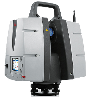
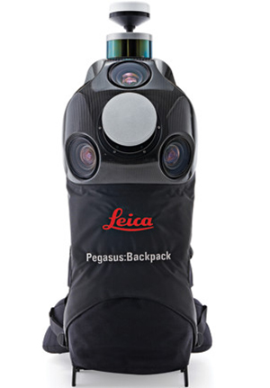
We trialled the Leica ScanStation P40, used more commonly on construction sites, and also a Leica Pegasus:Backpack mobile mapping platform, designed to scan as a user walks around a project.

The BLK360: ideal validation tool
What did the trials involve?
We trialled all three instruments on a £6m project to refurbish the listed Coupland Building at the University of Manchester. The four-storey building will feature a large new atrium, cut through the centre, new lifts, various existing materials will be removed, restored and reinstated.
The building has lots of nooks and crannies, coved ceilings and other intricacies, and reality capture was used to record exactly what was there at the outset so that when everything is reinstated, we can prove we haven’t impacted on the listed qualities of the building.
During the trials we compared the time it took to carry out a 3D scan, the resolution produced, and general results in terms of usability and suitability for the job. All systems produce a point cloud with an HDR image mapped over the top so the 3D scan looks like a high resolution 3D photo.
Walking around the laser scan feels like walking around the real building, but the software enables you to simply take measurements such as a door width, or the floor-to-ceiling height, etc.
Which one was best?
If we were to purchase one today from a BIM perspective, it would be the Leica BLK360. It was the ideal validation tool to confirm what we built on site matched up with what the 3D model set out. It was also small, lightweight and very user friendly and produced good purposeful information well suited to our needs.

The Leica ScanStation: Most accurate
The Leica ScanStation P40 produced the highest accuracy data set, and is, therefore, the best option for a site engineer wanting to ensure a high degree of precision, for example when planning where to knock holes through a building or tear down walls. If you have a high level of expertise and skill, this is probably the right system for you.
The Leica Pegasus:Backpack unit had the lowest level of accuracy of all three instruments, with a tolerance of 30-40mm, compared to 3-4mm using the Leica BLK360 and 1-2mm using the Leica ScanStation P40. However, the mobility factor enabled us to capture the site in a very short space of time.
Graham Construction is involved in both building and infrastructure projects and this is the ideal choice for scanning a large section of motorway, for example. Building sites involve various physical obstacles and this mobile mapping platform made it possible for the user to walk around the objects or manoeuvre up and down stairs, etc.
How much faster was the Leica Pegasus:Backpack scan?
Significantly faster; it was possible to scan two entire floors of the building in about 15 minutes. It would be useful for reporting on progress to demonstrate that you have reached different stages of a project.

The Pegasus Backpack: fast results
You could send someone out to scan the building, then the QS back at the office could do a virtual walkthrough to see what walls have or haven’t been built, or what has or has not been demolished for example.
It is a good method for bringing the project back to the office without having to take everyone out onto site for an assessment.
How is the Leica BLK360 operated?
It’s very simple; you set it up with a single button press, so we could send out pretty much anyone on site to create scans. It was able to scan a large room in about three minutes, and you can view the results instantly on an iPad to check you have got it right. When you move it to the next scan location, it recognises how far you have moved it and is able to stitch together the various scans.
The floor we scanned involved 13 setups, which we were able to stitch together on site on the same day. As a result, we recorded the point cloud processing time as “zero” because we did it in real time. In contrast, the Leica ScanStation P40 had a processing time of around 1hr 30mins and the Leica Pegasus:Backpack about 40 minutes.
Images: http://leica-geosystems.com


